Wednesday, September 19, 2012

Fern Lake


Yes, there are ferns along the trail to Fern Lake. And in the fall, they turn yellow and crunchy, providing a different texture to all the other autumn colors and shapes.


Creeks are low, even lower this year than previous Septembers. Feels like the bridges are unnecessary now.

I call them my magic trees. Along the trail to Fern Lake are a number of trees that are either split or hollowed out. Hikers put little rocks inside them. They tunble down, are rebuilt, providing a little hidden artwork along the way.

At Fern Lake, Clyde, Maggie, Fran, Janet, Rick (and Muneca) and Barbara.
Posted by Picasa

Friday, September 14, 2012

Deserted Village


Continuing my week of visiting old structures in and around the park, today we headed to Deserted Village on the North Fork of the Big Thompson. Once a hunting lodge, now just bits of one small cabin remain.


Margy, Clyde (with Muneca), Fran and Maggie at Deserted Village. Knowing that the season of summer hiking is coming to a close and that we will all be heading in different directions in a few weeks, we've been savoring every step.

Taking a "shortcut" back to the parking lot found us winding steeply through a small drainage. Finally we topped out and hit a dirt road, where the aspens were shining.
Posted by Picasa

Thursday, September 13, 2012

Game Drive Walls


Up on the tundra are remnants from an earlier era when the herds were hunted. In order to direct the animals towards the hidden hunters, game drive walls were built. An easy hike up on Tombstone Ridge brought us to these walls, but they are scattered all over the tundra if you keep your eyes open. Look for a string of somewhat parallel rocks.

The tundra was windy and cold, although the sky was still blue. How long until the first snows cover the land above the trees?
Posted by Picasa

Tuesday, September 11, 2012

Lulu City


The colors appear to be changing early this year, but the trees look vibrant and full, as if they will withstand the first strong wind or rainstorm. Maybe it was because we were on the west side of the divide where the trees have more moisture.

Today we hiked up to the remains of Lulu City, a deserted mining town near the headwaters of the Colorado River. The river is just a tiny stream up here, but a couple hundred folks followed their dream to this valley.

Although the site is gorgeous, very few artifacts remain. A few logs from a foundation here, a depression in the ground over there, a ditch that might have channeled the water from a nearby stream. And a trail that was used for daily stage coach travel from Grand Lake to Ft Collins.

Maggie, Jean, Linda, Megan with Muneca, and Barbara at Lulu City.


Tuesday, September 4, 2012

Twin Lakes

 Propped up on a small bench with beautiful views into Wild Basin lie Twin Lakes. From the western lake Tanima takes center stage, flanked by Mahana and Mt Alice. It the shadows are just right, you can see Eagle's Beak rising up in the drainage between Mahana and Tanima. But the best part of these lakes is the solitude. I have never had to share the lakes with another human who wasn't on the hike, only otters and birds.It's the perfect place to spend a few hours of solitude.

 We bushwhacked over to the smaller eastern lake, climbing lots of boulders and passing through a beautiful stand of aspen. The second lake is covered in lilies, but only the leaves remain this season. 

Greg, Cathy, Muneca and Maggie at Twin Lakes. Deciding to find an alternate path back to the trail, we followed the dry outlet stream. Without too much trouble, we found our way back to the main trail and avoided the worst of the krumholz. A leisurely stroll past Ouzel Falls and Calypso Cascades completed a perfect September day.

Sunday, September 2, 2012

Sky Pond

 The summer is always nearing its end before I get a chance to lead a hike up to Sky Pond. And I always wonder why I don't go there more often, as there are so many incredible sights along the way. Under aspen ready to start glowing, past Alberta Falls, and then to our first lake of the day, The Loch. The wind had a certain fall chill, but the skies were staying bright with just a few puffy clouds racing over the summits. 

 On the far side of The loch, and up an incredible number of stone steps, lies Timberline Falls. Water pours over the falls all summer, catching the light to make it appear weightless. To the right of the falls, the trail climbs straight up the wet rocks. A little scramble and the upper gorge opens up. 

 While we were sheltered from the wind while we climbed the falls, there was no protection upon reaching Lake of Glass. But it doesn't matter - the view is worth it. Just put on another layer and enjoy. 

 Following the rocky ledges to the right of Lake of Glass, we climbed further into the gorge and arrived at our destination, Sky Pond. The mountains tower over you, feeling like they are closing in. All is gouged out rock, transformed into cliffs and spires by the force of the glaciers 20,000 years ago. 

 Our group at Sky Pond - Kim, Andrew, Rich, Lisa (with Muneca), John, Richard, Maggie and Boyang.

As we trekked back down the trail, we reentered the aspen forests. Color changes seem to be appearing overnight. A whole hillside of bracken was already dressed for autumn.

Friday, August 31, 2012

Black and Blue Lakes

 Today was a hikemaster holiday. All of our hikes were cancelled, so Sarah, Clyde and I set out for Upper Glacier Gorge and Black and Blue Lakes. After we reached Mills Lake, we hiked further up the gorge through the mile or so of downed trees. The power of the wind that hit the area last November is hard to imagine. Above Shelf Creek, the landscape returns to normal, as if nothing had happened. Black Lake was waiting for us with a crystal blue sky overhead and wonderful reflections of McHenry's and Arrowhead. 

 Following Glacier Creek up the gorge, we struck off the trail when it started heading to the south. We stayed north and east, climbing several rocky benches, until we topped out at Blue Lake, located on its own enormous bench with a view of the immensity of upper Glacier Gorge. Spearhead rises to the south, encircled by the high peaks of Longs, Pagoda, Chiefshead, and McHenry's. 

 Muneca was joined on this hike by her friend Jack Strong. She had been wondering what he had been up to all summer.

 Sarah, Maggie, Clyde, Muneca and Jack Strong at Blue Lake. 

 Just above Black Lake, water seems to seep from the granite into little waterfalls. The granite walls are so smooth here, it would be a perfect slide if it weren't vertical.

As we headed back down the fire trail, we could see signs that the summer is nearing an end. Patches of aspen are beginning to turn gold. Where has August gone?

Thursday, August 30, 2012

Isabelle Glacier

 Another early morning hike from Brainard Lake. Several large bull moose have been hanging out in the area this summer. Would we be lucky enough to spot one? Roy kept an eagle eye as we headed on the trail to the south of Long Lake. Not too far down the lake, he spotted Mr Moose enjoying his breakfast. After a quick glance our way, he resumed his meal. 

 Further up the trail we arrived at Isabelle Lake. Although the water in the lake is being drained to the thirsty plains as it is at the end of every summer, there is still plenty in the lake. There wasn't  a breath of air to disturb the mirror-like reflections of Navajo and Apache in the distance. 

 The exposed lake bottom in the shallow areas showed the evidence of the recent drainage. 

There is so much water draining this area, there are cascades everywhere. At the end of the valley, willows and marshes make the trail interesting to follow and easy to get a muddy boot or two. 

Despite the brilliant blue skies as we ascended above Lake Isabelle, within half an hour the skies were grey and angry. After several loud thunderclaps, we turned around about 10 minutes before reaching the glacier overlook. Next time...

Wednesday, August 29, 2012

Flattop and Hallet

 The summer is definitely fading. It's surprisingly dark at the trailhead at 6am. But the Aspen Creek school kids were ready to hit the trail and scale Hallett in the distance. 

 With four and a half miles of trail under our belts and a belly full of snack food also under our belts, we arrived at the summit of Flattop. The crevasses of Tyndall Glacier opened up before us.

 A short walk along the rocks and tundra and then we started the real climb to the summit of Halletts. Mountain views surrounded us on all sides. We stopped for lunch in one of the wind shelters. I was amazed that there was any food left in those lunch boxes, but turkey sandwiches and oreos kept emerging. 

At the summit - Maggie, Roy, Quinton, Brevitt, Dillon, Bryan, Preston (and Muneca), Nico, and Colt. Lots of songs from the 80's kept us going on the way down. I think I have the phrase "I want to rock. Rock" imprinted on my memory, with a side of Journey lyrics. Thanks to all for a wonderful day!

Thursday, August 23, 2012

Specimen Crater

Bighorn sheep like their solitude.  In the summer they are hard to find and want to keep it that way. I have often seen them on the way to Mt Ida, but one of their favorite hangouts is Specimen Crater where they can lick the mineral deposits. However, they have been getting a little agitated by all the human attention over the years, so the trail to the Crater is closed until mid August, and lambing season is long finished. The downside to this is that it's now difficult to find a bighorn in the Crater. But the hike up through the subalpine forest and the view at the top is still worth the trek.

Despite the chill in the air, we settled down on the top of the crater to see if any bighorns would materialize. Lucas found the perfect perch with a soft tundra backing.


 You cannot hike into the Crater or up to Specimen Mountain, but you can continue on to Shipler Mountain a little to the south.

 Our group at Specimen Crater

We finally found our bighorn sheep when a few of us stopped at the Alpine Visitor Center for some coffee and hot chocolate.

Tuesday, August 21, 2012

Mount Chapin

 One of the easiest hikes to get above treeline and enjoy the tundra and a summit is to head to Mt Chapin. Although the trail is only a couple of miles, you know that you are in oxygen deficit from the first few steps because you are starting out at 11,000 feet. 

 After the first half mile, the trees start to disappear and the vistas open up. The trail heads up the grassy north side of the mountain. Rock fields are scattered along the way where pikas and marmots tend to pop out, greet you, and then scurry away. 

 If you are ambitious, you can continue further on the Mummy Range to Chiquita and Ypsilon. The grassy slopes allow you to make good time when the weather is good, but the rocks can get pretty slippery when it rains. Have I mentioned before that the Mummy Range appears to be a magnet for the thunderstorms that pass through the area?

The heart shaped rock obsession continues. James found a rock just for Muneca.

Monday, August 20, 2012

Pear Lake

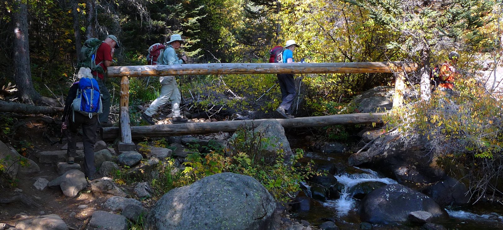
 So many of my favorite places in the park are not just beautiful destinations but amazing journeys. Today our destination was Pear Lake, and I decided to reach it via "the elevator" alongside Cony Creek. A mile of tumbling water and the last of the season's wildflowers started the adventurous part of the hike. There is a log crossing along the way, and I always joke that this is it. Join me next time on this hike and you find out what it really looks like. 

 Another perfectly calm day as we reached Finch Lake. I'm beginning to think that the wind is always calm here - I have so many perfect reflection photos. 

 A few miles further up Cony Creek, we reached our destination, Pear Lake. It used to be one of the reservoirs in the park, along with Bluebird, Sandbeach and Lawn. After the Lawn Lake dam broke, they dismantled the remaining dams. There are still signs of the previous shoreline, but many small shrubs have sprung up among the rocks. Copeland Mountain rises from the far side of the lake. 

 Merika, Maggie. Tim, Morgan (with Muneca), Dawn, Theresa, James, Marybeth and Tommie at Pear Lake. 

 The Hoefts had an ambitious week of hiking ahead of them. I think this photo shows that they had not completely adjusted to the lack of oxygen. 

 It's not often that Muneca and I get our own photo. It seemed fitting that it was at Pear Lake in light of the many memories I have of it. We have often camped at Pear on our anniversary - hours of incredible scenery accompanied only by the sounds of the wind and a few birds. Fishing in the early morning and early evening. Hiking through meadows of avalanche lilies. Exploring Hutcheson Lakes. Plenty to do for several days. 

 The bottom part of 'the elevator' is aptly named, except that there is no motorized assistance. 
 
At the end of the hike, we hopped over to Copeland Falls. The trailhead is close, but the falls look so inviting. One day, I'm going to have a nice swim in there. Anyone have a wetsuit?