Coming March 2020.
After a lot of introspection Muñeca has convinced Richard that an adventure across the Silk Road from Europe to Mongolia would be an extremely enjoyable jaunt.
With early planning now taking place and plenty of maintenance to the KTM 690 ( Moto Naranja ) it is hoped that the Silk Road will be ready to divulge some of its timeless secrets in March, 2020.
Wednesday, July 17, 2019
Sunday, April 15, 2018
Cusco to Lima
 |
| Five up |
 |
| Cusco Main Square |
After returning from Machu Picchu I spent a few days in the magnificent old Inca capital of Cusco. There are so many churches in the city as the Spanish, upon arrival, demolished all the Inca palaces and built churches on the foundations as a way of showing there dominance.
 |
| Two bull roof ornaments |
Many houses have these two bulls adorning their roofs to protect against evil spirits
 |
| Beautiful carved wooden balconies |
The houses of the nobility had carved wooden balconies
 |
| Sacred Valley |
Here was the start of the Sacred Valley with the Urubamba River running through the middle
 |
| Colorful Pisac Market |
The town of Pisac has an incredibly colorful market not only selling plenty of touristy stuff but plenty of food, fruit and vegetables as well. Traditional clothing mixed seamlessly with backpacker chic and less chic hippie matted hair.
 |
| Inca Ruins at Pisac |
The ruins above the town were very impressive with stone citadels perched way above the valley floor and huge stone terraces where the Incas grew their crops
 |
| Moray Terraces |
A few kilometers down the valley brings you to the stone terraces of Moray which is thought to have been an Inca agricultural experimental station where they studied the effects of different microclimates on their crops
 |
| Stonework at Ollantaytambo |
 |
| Sun Temple |
The Sun Temple is the most amazing example of this rock carving technique with expansion joints between the polished granite pieces that have withstood the ravages of time as well as numerous earthquakes without having moved a millimeter
 |
| Carved Lock Piece |
 |
| Urubamba River |
 |
| Muddy Mountain Road |
I had mapped out a route through the mountains which I hoped was passable as some maps showed a road being there but others just a region devoid of even tracks. The roads were in fact there but not in exactly the places that my GPS Open Source Maps showed but it certainly added a bit of excitement. This soft muddy section brought traffic to a standstill as a truck sunk up to it's axles in the mire. Easy going for my trusty KTM
 |
| Many Stream Crossings |
I crossed so many little streams on one section as I worked my way up into the rain forest. Often I could not see what the surface was like or see the rocks lurking on the bottom. At one point I nearly dropped the bike in the river which would have been a miserable experience as it was starting to get dark and the temperature was dropping quickly as mist and light rain rolled across the lush undergrowth. This was a very strange area as I did not see another vehicle for over an hour and passed through a number of abandoned villages. This was an area of intense guerrilla activity during the days of the Shining Path wars that depopulated vast areas of the high mountains of central Peru

It was a little unnerving waiting my turn to squeeze part this truck that had been caught in a landslide, especially as rocks and debris kept raining down onto the road in front of me - maybe I should have waited further back up the road where I had been told to.

With no room for error vehicles managed to barely get through between the truck and oblivion
 |
| Great Road Sign |
I love this road sign and the name of a horn being a claxon somehow just appeals to me
 |
| Squatting is a problem? |
Talking about blowing your horn - you gotta be kidding that this is a problem!!!
 |
| Mountain Scenery |
After 5 days of riding through some most amazing scenery it was time to get to Lima
 |
| Beautiful Stone Bridge |
Dropping down into stunning river valleys
 |
| Limestone Mountain Scenery |
and through areas of stark limestone mountains I joined the main road at the gold mining town of Oroya. From here the road ascended into the clouds at an altitude of 4810 meters ( nearly 16,000 ft ). The road was almost bumper to bumper trucks with cars suicidally passing on blind curves with thick mist and snow making it impossible to see the heavy laden gasoline trucks coming in the other direction. After the pass I descended for almost two hours under some of the worst road conditions I have seen on my entire trip - it was downright scary with cars forced off into ditches by passing trucks with no regard to life or limb. I decided to find a place to stay for the night as I did not then want to deal with Lima traffic at the end of an extremely taxing day.
And now here I am in Lima, this sprawling city of 8 million inhabitants.
Having now completed the loop of South America and having been on the road for over 13 months it is now time to find a way to ship Moto Naranja home. I expect it will take me a week or so to sort out the logistics but I have decided that this is the end of the road for this incredible adventure.
In some ways I am sad but but also so very grateful for having this opportunity to live my dream. It started with a heavy heart with the then recent loss of Maggie, my amazing, wonderful wife of 33 years but ends with a new sense of wonder and happiness. The road really has helped me to heal and come to know that love shared is love that can never be lost.
Saturday, April 7, 2018
Machu Picchu Peru

 |
| Machu Picchu in all its glory |


 |
| Inquisitive locals |
 |
| The Sun Temple |
 |
| Main Temple and sacrificial altar |
I took the long route to Machu Picchu by doing the five day Salkantay Trek that wound its way through the mountains
 |
 |
| Lake Humantay |
 |
| Mount Salkantay - 6271m , 20574 ft |
The second day of the hike was the most strenuous at 22km which crested out at over 4000 m ( 15,000 ft) at Salkantay Pass before dropping down rapidly into the jungle below.

We passed through numerous little villages and the tour company would be waiting for us at one of them with a cooked lunch.

At night we would stay in permanent camps in villages with once again plenty of hot, good food. The entire tour with all meals provided, entrance to Machu Picchu and transportation cost a total of $170 - what incredible value for money.
One morning I woke with painful blisters between my toes, not from hiking but from dancing ( or at least my version of that difficult art form ) for hours with the fun group of people from all over the world that were my fellow travelers for a few days. I was the oldest by at least 25 years but after a couple of beers and Inca Tequilas age and cultural differences were forgotten and I embarked on the difficult task of teaching them all Poephol Cricket.
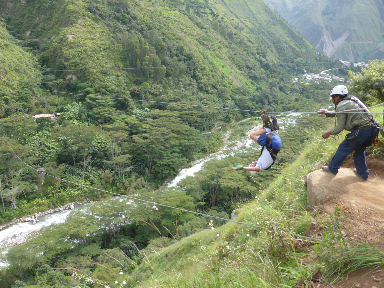 |
| Upside down Zip Lining - this is not me |
One day we had the option to go zip lining with four lines stretching over a canyon, one of which was over 1 km long. The upside down traverse was the most disorienting but most exhilarating of the morning.
And then came the final 13 km along the railway track from Hidroelectrica to Aguas Calientes, the town at the base of Machu Picchu where we spent a night before waking up at 3.30 am to begin the hike up the mountain.

 |
| Aguas Calientes main "street" |
Wednesday, March 28, 2018
Camino de la Muerte -- Death Road Bolivia

The Camino de la Muerte or Road of Death is aptly named because when it was still the main road from La Paz to Coroico it had the infamous reputation of killing as many as 200 people a year. It is now really a shadow of it's former glory as all the busses and trucks travel on a paved road leaving the cliff hanging track to thrill seeking foreigners.

Water cascades off the mountain in places to add to the thrills

There are many crosses along the way as more than just a gentle reminder to go easy on the throttle

I ended up riding the road twice as the first day it was raining with heavy mist which made the riding a little more treacherous but also I never got to see the incredible views. Having unexpectedly found myself alive at the bottom of the 2000 meter descent I decided to to it again the following day when the weather was so much better.
 |
| What's wrong with this clock |
 |
The Congress Building in La Paz where the clock goes backwards. It actually runs clockwise because the numbers are in the opposite order of a conventional clock. This has been called "The Clock of the South
 |
| Wiring nightware |
 |
| Crowded Streets |
 |
| Witches Market |

A lot of woman still wear traditional clothing with the ever present bowler hat


This city of nearly a million people is situated in a valley at 3600 meters ( almost 12,000 ft ) above seal level. There are what I would call ski gondolars that ring the city ready to whisk people over the rooftops and up to the rim of the valley to avoid the incredibly congested streets. Riding my bike through the streets was hell.
 |
| View of La Paz from Alto |
Back to the tranquility of the tropical climate at the bottom of Camino de la Muerte I spent a few days in the town of Coroico - paradise

 |
| Hostel Sol y Luna |

The lush tropical climate made the beautiful gardens of Sol y Luna an amazing place to relax for a few days after the madness of LaPaz

View of the valley from Sol y Luna above the town of Coroico
After spending some time thinking on where my maps would next lead me I plotted out a route east and then north from Coroico going through the towns of Caranavi and Guanay and then to Mapiri with the intent of crossing back over the high mountains before dropping down to Lake Titicaca.
The road looked doable although both my Garmin and Google maps would for some unknown ( at the time ) reason not trace out this route. However I spoke to some local people and there was no doubt the road existed and could be done - given the right conditions.
 |
| Rio Coroico |

I climbed up out of the valley on a winding road and stopped to take a photo of the excavations going on below me. As I stopped the much anticipated but totally unexpected blast took place across the valley from me -- I nearly S**t myself !

What an amazingly beautiful ride through the jungle
 |
| Many river crossings |
 |
| Repairs needed |

I spent that night in the town of Guanay which was surrounded by lush tropical vegetation and farmlands. The next morning I awoke to light rain and mist and although I had been told that the road from here onwards could become impassable in wet weather I decided to give it a go.

For a start it was great not having to deal with any dust and the slightly damp dirt road had great traction making for some fun riding. However this changed dramatically once I started climbing higher and the rain got harder. The red clay became like a skating rink.

After the wheels became caked in clay it was almost impossible to keep the bike going in a straight line and the downhills were just downright terrifying. I finally dropped the bike and slithered to a stop covered in mud from head to toe. With a little help from a passing 4 wheel drive I got the bike upright but decided it best to turn around, especially as the huge black cloud higher up the mountain is where I was headed.
So three hours after setting out I was back in the town of Guanay just as the locals were coming out of church on Palm Sunday, all waving beautifully woven palm crosses. After a meal at a restaurant on the town square I then set out on the long road all the way back to La Paz where I arrived late that evening.

The next morning bright and early I was off to Lake Titicaca and with the help of a ferry arrived in the town of Copacabana. Yes, all you school kids who snickered at the name of this lake, it does exist and that is how you spell it.
 |
| Basilica of our Lady Copacabana |
 |
| Isla del Sol |

 |
| Inca ruins of a nunnery on Isla de la Luna |

This wall on the same site is pre - Incan. Just look at the intricate stonework with the interlocking blocks, so precise that you would be unable to slip a piece of paper between the cracks

A papyrus craft much like the one constructed by Thor Heyerdahl in the 1970's for his Ra I and Ra II expeditions ( ok you are going to have to Google that one yourselves ! )
That's it for now -- next stop Peru
Subscribe to:
Posts (Atom)