Wednesday, March 28, 2018

Camino de la Muerte -- Death Road Bolivia


The Camino de la Muerte or Road of Death is aptly named because when it was still the main road from La Paz to Coroico it had the infamous reputation of killing as many as 200 people a year. It is now really a shadow of it's former glory as all the busses and trucks travel on a paved road leaving the cliff hanging track to thrill seeking foreigners.


Water cascades off the mountain in places to add to the thrills


There are many crosses along the way as more than just a gentle reminder to go easy on the throttle


Going downhill you have to drive on the left side, the reason for this is so that the driver of a car or truck can see how close to the edge his front wheel is - it's all about safety you know.
I ended up riding the road twice as the first day it was raining with heavy mist which made the riding a little more treacherous but also I never got to see the incredible views. Having unexpectedly found myself alive at the bottom of the 2000 meter descent I decided to to it again the following day when the weather was so much better.

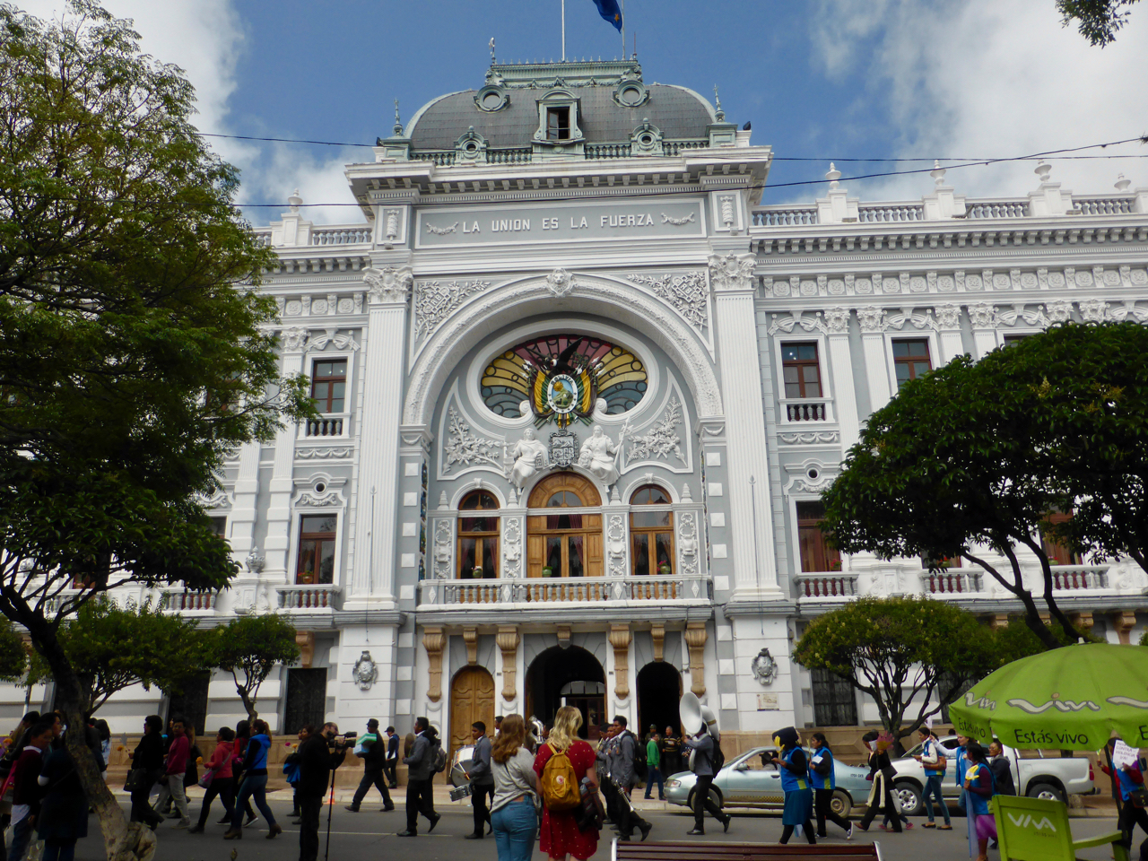
What's wrong with this clock
To keep things in chronological order I should say a little about the three days I spent in La Paz before I starting riding on crazy roads through the mountains


The Congress Building in La Paz where the clock goes backwards. It actually runs clockwise because the numbers are in the opposite order of a conventional clock. This has been called "The Clock of the South


Wiring nightware


Crowded Streets

Witches Market


A lot of woman still wear traditional clothing with the ever present bowler hat


This city of nearly a million people is situated in a valley at 3600 meters ( almost 12,000 ft ) above seal level. There are what I would call ski gondolars that ring the city ready to whisk people over the rooftops and up to the rim of the valley to avoid the incredibly congested streets. Riding my bike through the streets was hell.

View of La Paz from Alto

 Back to the tranquility of the tropical climate at the bottom of Camino de la Muerte I spent a few days in the town of Coroico - paradise


Hostel Sol y Luna


The lush tropical climate made the beautiful gardens of Sol y Luna an amazing place to relax for a few days after the madness of LaPaz


 View of the valley from Sol y Luna above the town of Coroico


After spending some time thinking on where my maps would next lead me I plotted out a route east and then north from Coroico going through the towns of Caranavi and Guanay and then to Mapiri with the intent of crossing back over the high mountains before dropping down to Lake Titicaca.
The road looked doable although both my Garmin and Google maps would for some unknown ( at the time ) reason not trace out this route. However I spoke to some local people and there was no doubt the road existed and could be done - given the right conditions.

Rio Coroico
I started out following the Rio Coroico down the valley on a good asphalt road only to be stopped by road works about 20 km from the town of Caranavi. Initially I was told they were doing some blasting and excavation and I should be able to go on in about 15 minutes. I asked again after about half an hour and was told it was going to be closed until 5pm that evening - it was 10am in the morning at this point. A taxi driver told me that it was possible to take the " jungle road" but it would take about 2 hours. As I could see the road on my Garmin I decided to chance it.


I climbed up out of the valley on a winding road and stopped to take a photo of the excavations going on below me. As I stopped the much anticipated but totally unexpected blast took place across the valley from me -- I nearly S**t myself !


What an amazingly beautiful ride through the jungle

Many river crossings


Repairs needed
All was going well until I went to hit the back brakes at a corner - nothing!! Somehow I wrangled the beast around the bend and stopped to see what the heck just happened. The rough road had dislodged my extra fuel canister ( never to be seen again ) and the bungies strapping it down had got stuck in the rear brake calipers. It took me nearly two hours to fix the problem as a few parts had got bent and a could not work out why the rear brake pads would not stay in place. Anyway sitting on the side of the road on the edge of a stream in the most amazingly beautiful place with large azure blue butterflies landing on and around me I could not be too pissed off about having to make repairs to Moto Naranja


I spent that night in the town of Guanay which was surrounded by lush tropical vegetation and farmlands. The next morning I awoke to light rain and mist and although I had been told that the road from here onwards could become impassable in wet weather I decided to give it a go.


For a start it was great not having to deal with any dust and the slightly damp dirt road had great traction making for some fun riding. However this changed dramatically once I started climbing higher and the rain got harder. The red clay became like a skating rink.


After the wheels became caked in clay it was almost impossible to keep the bike going in a straight line and the downhills were just downright terrifying. I finally dropped the bike and slithered to a stop covered in mud from head to toe. With a little help from a passing 4 wheel drive I got the bike upright but decided it best to turn around, especially as the huge black cloud higher up the mountain is where I was headed.
So three hours after setting out I was back in the town of Guanay just as the locals were coming out of church on Palm Sunday, all waving beautifully woven palm crosses. After a meal at a restaurant on the town square I then set out on the long road all the way back to La Paz where I arrived late that evening.


The next morning bright and early I was off to Lake Titicaca and with the help of a ferry arrived in the town of Copacabana. Yes, all you school kids who snickered at the name of this lake, it does exist and that is how you spell it.

Basilica of our Lady Copacabana


Isla del Sol


 This photo was taken looking back across Lake Titicaca from Isla del Sol with the snow covered Andes in the background.

Inca ruins of a nunnery on Isla de la Luna


This wall on the same site is pre - Incan. Just look at the intricate stonework with the interlocking blocks, so precise that you would be unable to slip a piece of paper between the cracks


A papyrus craft much like the one constructed by Thor Heyerdahl in the 1970's for his Ra I and Ra II expeditions ( ok you are going to have to Google that one yourselves ! )

That's it for now -- next stop Peru


Sunday, March 18, 2018

A week in Sucre, Bolivia

I decided it was time to give my terrible language skills a boost and enrolled in Spanish lessons in the beautiful city of Sucre, judicial capital of Bolivia. There is some confusion as to which city is the actual capital of this country with Sucre being the constitutional capital and the legislative and executive branches of the government based in La Paz.

Bolivia Coat of Arms
What a colorful and vibrant city Sucre is with something going on in the main plaza almost every lunchtime and evening. The Bolivians love their brass bands

Police Brass band
This little old lady decided she was going to join the police band as they practiced in the gazebo in the plaza


and started dancing much to the delight of the crowd and members of the band


Sucre is sometimes referred to as the white city with many of the old colonial buildings painted brilliant white with red terra-cotta tile roofs

Mercado Centro
The Mercado Centro was a great place to go at lunchtime to either pick up some fruit or to get a two course meal of soup ( a meal in itself ) with a chicken or beef dish with rice and potatoes for the incredible sum of less than $3

University of Saint Francis Xavier
The University of Saint Francis Xavier was founded in 1624

The Supreme Court

Recoleta District


View down on the city from Recoleta
After ten days in the city it was time to hit the road again with a two day ride to La Paz passing through some magnificent scenery along the mountain road with small villages and farms dotting the countryside.


Lunch stop in the village of Macna

Stone walled fields

And now to explore La Paz


Monday, March 12, 2018

To the Mines

What does it take to become a miner in Potosí Bolivia

All decked out and ready to go mining
Apart from the required work clothes, helmet and headlight a few other supplies were needed before heading off to the silver mines at 4000 metres ( 13,000 ft ) in the Cerro Rico ( Rich Mountain ) in Potosí.

Dynamite
It was easy enough to pick up some dynamite ( Nitoglycerin, Ammonium Sulphate and fuses ) at the local miners market.


A bottle of 96 proof grain alcohol to lighten the mood and make the work day a little more enjoyable

Coca Leaves
Coca leaves to give energy and to counter the effects of the rarified air

Volvo - not!
All pile in the "tour bus" and enter one of 1500 working mines in this silver mountain that has been continuously mined since 1545

Mine Entrance
Each of the mines is run as a co-operative with the miners setting their own working hours, deciding on where they want to dig in the mines and also deciding, with little warning when they are going to set off their dynamite charges.


A little cramped in here


The mines brought enormous wealth to the Spanish and incredible hardship to the early miners / slaves and built the city of Potosí which was considered in the late 16th century to be the richest city in the world.


Cerro Rico standing watch over the town

A wet ride of a couple of hours through beautiful scenery brought me to the capital city of Sucre


Swollen rivers from all the rain

Welcome to Sucre

I stopped outside a hostel and went in to enquire if there was accommodation available and not five minutes later an over-ambitious cop had given me the BOOT - NOT VERY NICE!! It took a little while to work out how to get Moto Naranja released from jail.

Beautiful buildings surround the plaza